The main aim of the project is to prepare a critical study and on-line publication of Geographical and Statistical Description of Parishes of the Kingdom of Poland (Geograficzno-statystycznego opisania parafiów Królestwa Polskiego) and Karol Perthées’ special maps of the Crown’s voivodeships. Both of these sources are fundamental and extremely valuable for any research of the cultural, historical and political landscape of the Polish lands in the second half of the 18th century. They are kept at the Vladimir Vernadsky National Library of Ukraine in Kyiv. The on-going works are conducted simultaneously in three areas. Firstly, within the scope of documentation and cartographic research, the project team is preparing a depiction of the settlement network and administrative divisions of the Crown (within its pre-second-partition borders). Secondly, within the scope of problem-oriented research, the collected material serves as the main source for a series of publications and a monographic study on “Cartography at the service of state reforms in the times of Stanisław August Poniatowski”. The term cartography is understood here very broadly, as a whole procedure in which maps are merely the result of actions undertaken for military, administrative or fiscal reasons (Skelton 1972). Thirdly, the project also deals with theoretical and methodological issues related to editing and elaboration of historical sources, in particular cartographic ones, and the collection of geographical and historical data (spatial and temporal databases).
The idea of the project arose from the overarching question about the role played by space organisation in the process of shaping modern society in the Polish-Lithuanian Commonwealth during the reign of King Stanisław Agust. Development of territorial administration is one of the elements indicating the level of modernisation of the state and society. In their historical development, territorial divisions of any country are derivative of its governing and social structures – foremost those of the military administration, but also the fiscal and judicial apparatus (bureaucracy). The quality and precision of cartographic depiction of countries improved with increasing modernisation, as well as organisational and administrative development. This phenomenon is notable in France of the 17th century, and Brandenburg-Prussia and the Habsburg monarchy in the 18th century. A. Mączek emphasised this process as the evolution from the estate system to a centralised system of state administration (Mączak 1986), but it is also worth taking a closer look at the significance of the manorial system and church administration for the territorial order of the Polish lands. The awareness of the state as a territory, a space that must be “mastered” (Augustyniak 2008) in order to be efficiently managed, is very clear in the period of the reforms of King Stanisław August. It was reflected in a series of mapping and census activities carried out by the king’s cabinet, with the support of the primate’s court, which resulted in parish surveys, descriptions and sketches of the country, as well as maps created in 1778-1804.
The project constitutes a continuation of documentation and cartographic works began in the 1960s by the Department of Historical Atlas. It refers also to the older tradition related to the postulates of F. Bujak (1905) and W. Semkowicz (1922) that suggested creating detailed maps for several time periods, including the period of the fall of the Polish-Lithuanian Commonwealth (Herbst 1978). This postulate was implemented only in a limited scope – for the former Cracow voivodeship (Semkowicz, Buczek 1930). As 2021 brought the end of the Historical Atlas of Poland in the 16th century project (National Programme for the Development of Humanities no.: 1aH 15 0373 83, headed by prof. Marek Słoń), it is now possible to refocus the work effort on the second half of the 18th century, verifying the research assumptions and the adopted methods. The methodological solutions adopted for the project will make it possible to not only edit the historical sources, but also create the first detailed map of the settlement network and territorial divisions of the Crown in the second half of the 18th century (within its post-first-partition borders) within 5 years.
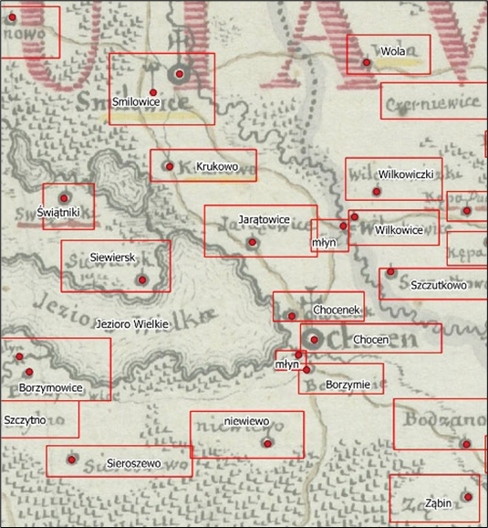
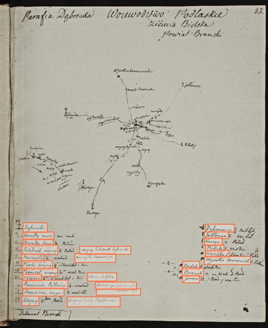
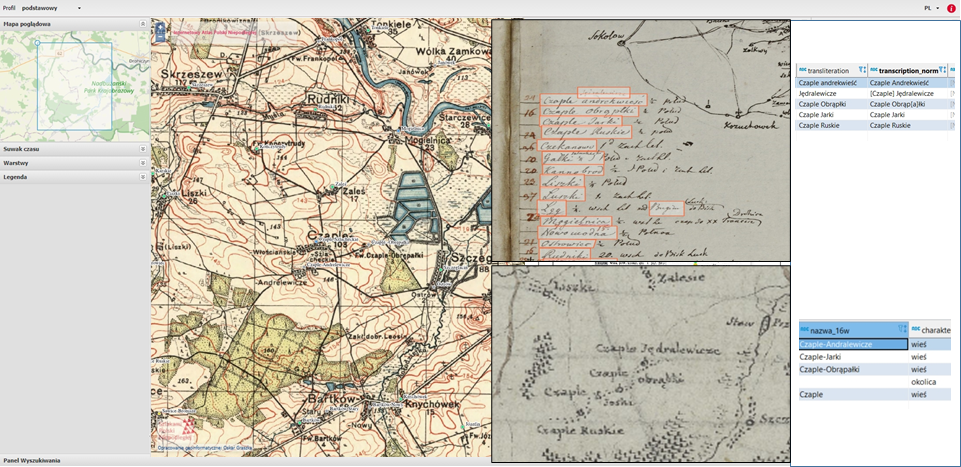
The main result of the project will be a database and a webGIS application presenting the Geographical and Statistical Description… and the special maps of the Crown’s voivodeships created by Karol Perthées. The application will present 5265 photos of the manuscript and 12 special maps with interactive links to all settlements and administrative units included in the sources. Proper names will be presented as included in the sources, and the references will link to the relevant geographic locations. The settlements and borders will be presented on the Military Geographical Institute’s 1:100,000 base maps from the interwar period. The application will be equipped with a search engine for settlements and administrative units. In addition to the webGIS application, WMS (Web Map Service) and WFS (Web Feature Service) services will be made available, giving open and free access to the collected data (both text and geographic attributes). It should be added that, in the course of the project’s implementation, the entire resource will be integrated with the data of the Historical Atlas of Poland in the 16th century, creating a harmonised dataset.
Augustyniak U., Historia Polski 1572-1795 [History of Poland 1572-1795], Warsaw 2008.
Bujak F., W sprawie kartografii historycznej [On historical cartography], “Studia Geohistorica“, 3, 2015, pp. 17–27.
Buczek K., Mapa województwa krakowskiego z doby Sejmu Czteroletniego (1788-1792). Źródła i metoda [The Map of the Cracow Voivodeship from the Four-Year Sejm Period (1788-1792). Source and Method], Cracow 1930.
Herbst S., Atlas na rozdrożu [Atlas at the crossroads], in: S. Herbst, Potrzeba historii czyli o polskim stylu życia [The Need for History, or about the Polish Lifestyle], vol. 2, Warsaw 1978, pp. 462–469.
Mączak A., Rządzący i rządzeni: Władze i społeczeństwo w Europie wczesnonowożytnej [The Rulers and the Governed. The Authority and Society in Early Modern Europe], Warsaw 1986.
Semkowicz W., Atlas historyczny Polski (program wydawnictwa) [Historical atlas of Poland (publication programme)], in: Prace Komisji Atlasu Historycznego Polski [The Works of the Commission of the Historical Atlas of Poland], vol. 1, Cracow 1922, pp. 1–16.
Skelton R.A., Woodward D., Maps: A Historical Survey of Their Study and Collecting, Chicago 1972.